Geolocate

Kinam topographic map

Click on the map to display elevation.

About this map

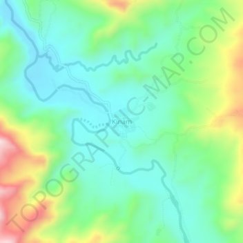
Name: Kinam topographic map, elevation, terrain.

Location: Kinam, Sarangani, Soccsksargen, Philippines (5.99503 125.39263 6.03503 125.43263)

Average elevation: 784 ft

Minimum elevation: 348 ft

Maximum elevation: 1,808 ft

Other topographic maps

Click on a map to view its topography, its elevation and its terrain.

Mainit River

Philippines > Sarangani

Average elevation: 915 ft

Sarangani Bay

Philippines > Sarangani

Average elevation: 338 ft

Malungon

Philippines > Sarangani

Average elevation: 1,522 ft

Glan River

Philippines > Sarangani

Average elevation: 1,260 ft

Maasim

Philippines > Sarangani

Average elevation: 676 ft

Buayan River

Philippines > Sarangani > Malungon

Average elevation: 489 ft

Gumasa Beach

Philippines > Sarangani > Glan

Average elevation: 197 ft

Malungon

Philippines > Sarangani

Average elevation: 1,509 ft

Malungon

Philippines > Sarangani

Average elevation: 1,522 ft

Gear up for your next adventure:

🪵Folding Camp Saw - Compact saw for wood and campsite work
🧯Emergency Survival Kit - All‑in‑one survival essentials for the backcountry
🎒Gear Packing Cubes - Organize your backpack efficiently
🕶️GPS Smartphone Mount - Secure mount for phone navigation
🪶Fire Starter Kit - Reliable fire starter for survival and camping

As an Amazon Associate, this site earns from qualifying purchases at no extra cost to you.