Geolocate

Tobu topographic map

Click on the map to display elevation.

About this map

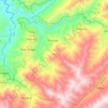
Name: Tobu topographic map, elevation, terrain.

Location: Tobu, Mon, Nagaland, India (26.28868 94.89673 26.41322 95.04461)

Average elevation: 4,449 ft

Minimum elevation: 1,358 ft

Maximum elevation: 7,966 ft

Other topographic maps

Click on a map to view its topography, its elevation and its terrain.

Tanhai

India > Nagaland > Mon

Average elevation: 2,310 ft

Gear up for your next adventure:

👓Polarized Sunglasses - Outdoor sunglasses for glare reduction
🚁Photography Drones - Capture stunning aerial views of landforms and topography
🪶Survival Guide Book - Expert advice for emergency preparedness
🗺️Topographic Maps - Detailed topo maps for hiking, exploring and outdoor navigation
🛰️Satellite Messengers - Emergency SOS and two-way messaging for off-grid adventures

As an Amazon Associate, this site earns from qualifying purchases at no extra cost to you.