
Make a donation
Gear up for your next adventure:
As an Amazon Associate, this site earns from qualifying purchases at no extra cost to you.
Dentergem topographic map
Click on the map to display elevation.
Make a donation
Gear up for your next adventure:
As an Amazon Associate, this site earns from qualifying purchases at no extra cost to you.
Dentergem
Dentergem ligt in Zandlemig Vlaanderen en wel aan de rand van het Plateau van Tielt. De hoogte bedraagt 12 tot 28 meter. De belangrijkste waterloop is de Oude Mandelbeek, feitelijk een oude loop van de Leie. Een belangrijke beek is de Spiebeek die uitmondt in de Oude Mandel. Natuurgebieden zijn de Meikensbossen en de Gavermeersen. Het Grote Routepad 128 (Vlaanderenroute) doet sinds einde 2007 de Meikensbossen aan.
Make a donation
Gear up for your next adventure:
As an Amazon Associate, this site earns from qualifying purchases at no extra cost to you.
About this map
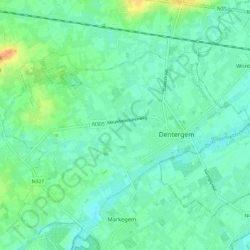
Name: Dentergem topographic map, elevation, terrain.
Location: Dentergem, Tielt, West-Vlaanderen, Vlaanderen, België (50.95065 3.36081 50.98167 3.44418)
Average elevation: 43 ft
Minimum elevation: 10 ft
Maximum elevation: 135 ft
Make a donation
Gear up for your next adventure:
As an Amazon Associate, this site earns from qualifying purchases at no extra cost to you.