Geolocate

Paris topographic map

Click on the map to display elevation.

About this map

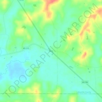
Name: Paris topographic map, elevation, terrain.

Location: Paris, Lafayette County, Mississippi, 38949, United States (34.15872 -89.47980 34.19872 -89.43980)

Average elevation: 397 ft

Minimum elevation: 328 ft

Maximum elevation: 531 ft

Lafayette County trails, hiking, mountain biking, running and outdoor activities

Other topographic maps

Click on a map to view its topography, its elevation and its terrain.

Abbeville

United States > Mississippi > Lafayette County

Average elevation: 361 ft

Sardis Lake

United States > Mississippi > Lafayette County

Average elevation: 341 ft

Gear up for your next adventure:

🔥Plasma Lighters - Windproof lighters that work in any weather condition
🪑Portable Camp Table - Compact table for campsite meals
🌐World Map Poster - Decorative world maps with topographic info
🧦Merino Wool Socks - Moisture-wicking, blister-preventing socks for long treks
🪶Fire Starter Kit - Reliable fire starter for survival and camping

As an Amazon Associate, this site earns from qualifying purchases at no extra cost to you.