
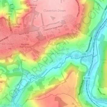
Monkton Combe topographic map
Interactive map
Click on the map to display elevation.
About this map
Name: Monkton Combe topographic map, elevation, terrain.
Average elevation: 335 ft
Minimum elevation: 62 ft
Maximum elevation: 584 ft
Other topographic maps
Click on a map to view its topography, its elevation and its terrain.
Old Mills
United Kingdom > England > Bath and North East Somerset > Paulton
Old Mills, Paulton, Bath and North East Somerset, West of England, England, BS39 7SR, United Kingdom
Average elevation: 413 ft
River Kennet
United Kingdom > England > Bath and North East Somerset
River Kennet, Bath and North East Somerset, West of England, England, RG1 6BT, United Kingdom, Kennet and Avon Canal
Average elevation: 154 ft
Clandown
United Kingdom > England > Bath and North East Somerset > Radstock
Clandown, Radstock, Bath and North East Somerset, West of England, England, BA3 3DW, United Kingdom
Average elevation: 387 ft
Peasedown St. John
United Kingdom > England > Bath and North East Somerset
Peasedown St. John, Bath and North East Somerset, West of England, England, United Kingdom
Average elevation: 410 ft
Batheaston
United Kingdom > England > Bath and North East Somerset > Batheaston
Batheaston, Bath and North East Somerset, West of England, England, United Kingdom
Average elevation: 374 ft
Bath
United Kingdom > England > Bath and North East Somerset
Bath, Bath and North East Somerset, West of England, England, United Kingdom
Average elevation: 328 ft
Chew Magna
United Kingdom > England > Bath and North East Somerset > Chew Magna
Chew Magna, Bath and North East Somerset, West of England, England, United Kingdom
Average elevation: 295 ft