
Make a donation
Gear up for your next adventure:
As an Amazon Associate, this site earns from qualifying purchases at no extra cost to you.
River Kennet topographic map
Click on the map to display elevation.
Make a donation
Gear up for your next adventure:
As an Amazon Associate, this site earns from qualifying purchases at no extra cost to you.
About this map
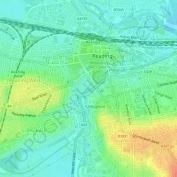
Name: River Kennet topographic map, elevation, terrain.
Average elevation: 154 ft
Minimum elevation: 105 ft
Maximum elevation: 256 ft
Make a donation
Gear up for your next adventure:
As an Amazon Associate, this site earns from qualifying purchases at no extra cost to you.
Other topographic maps
Click on a map to view its topography, its elevation and its terrain.
Tadwick
United Kingdom > England > Bath and North East Somerset > Swainswick
Average elevation: 528 ft
Make a donation
Gear up for your next adventure:
As an Amazon Associate, this site earns from qualifying purchases at no extra cost to you.
Chew Magna
United Kingdom > England > Bath and North East Somerset > Chew Magna
Average elevation: 295 ft
Batheaston
United Kingdom > England > Bath and North East Somerset > Batheaston
Average elevation: 374 ft
Make a donation
Gear up for your next adventure:
As an Amazon Associate, this site earns from qualifying purchases at no extra cost to you.