
Make a donation
Gear up for your next adventure:
As an Amazon Associate, this site earns from qualifying purchases at no extra cost to you.
Noyant topographic map
Click on the map to display elevation.
Make a donation
Gear up for your next adventure:
As an Amazon Associate, this site earns from qualifying purchases at no extra cost to you.
Noyant
L'altitude de la commune varie de 51 à 89 mètres, pour une altitude moyenne de 70 mètres.
Make a donation
Gear up for your next adventure:
As an Amazon Associate, this site earns from qualifying purchases at no extra cost to you.
About this map
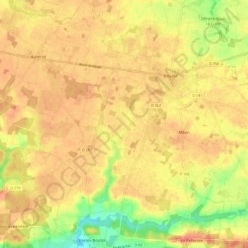
Name: Noyant topographic map, elevation, terrain.
Average elevation: 266 ft
Minimum elevation: 157 ft
Maximum elevation: 318 ft
Make a donation
Gear up for your next adventure:
As an Amazon Associate, this site earns from qualifying purchases at no extra cost to you.
Other topographic maps
Click on a map to view its topography, its elevation and its terrain.
Barrage des Mousseaux
France > Pays de la Loire > Maine-et-Loire > Noyant-Villages
Average elevation: 262 ft
Manoir de Breil de Foin
France > Pays de la Loire > Maine-et-Loire > Noyant-Villages
Average elevation: 256 ft
Make a donation
Gear up for your next adventure:
As an Amazon Associate, this site earns from qualifying purchases at no extra cost to you.