
Brown-Lowery Provincial Park topographic map
Interactive map
Click on the map to display elevation.
About this map
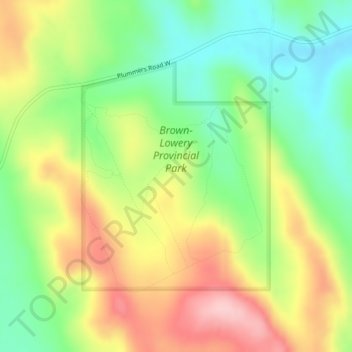
Name: Brown-Lowery Provincial Park topographic map, elevation, terrain.
Average elevation: 4,439 ft
Minimum elevation: 4,177 ft
Maximum elevation: 4,770 ft
Other topographic maps
Click on a map to view its topography, its elevation and its terrain.
Aldersyde
Canada > Alberta > Foothills County
Aldersyde, Foothills County, Alberta, T0L 1T0, Canada
Average elevation: 3,432 ft
Sheep River
Canada > Alberta > Foothills County
Sheep River, Foothills County, Alberta, Canada
Average elevation: 4,678 ft
Priddis
Canada > Alberta > Foothills County
Priddis, Foothills County, Alberta, Canada
Average elevation: 3,914 ft
Millarville
Canada > Alberta > Foothills County
Millarville, Foothills County, Alberta, T0L 1K0, Canada
Average elevation: 4,003 ft
Sheep River
Canada > Alberta > Foothills County
Sheep River, Foothills County, Alberta, T0L 2O0, Canada
Average elevation: 4,455 ft
Highwood River
Canada > Alberta > Foothills County > Village of Longview
Highwood River, Village of Longview, Foothills County, Alberta, T0L 1H0, Canada
Average elevation: 4,042 ft
De Winton
Canada > Alberta > Foothills County
De Winton, Foothills County, Alberta, T2V 3Z4, Canada
Average elevation: 3,622 ft
Cayley
Canada > Alberta > Foothills County
Cayley, Foothills County, Alberta, Canada
Average elevation: 3,510 ft
Hartell
Canada > Alberta > Foothills County
Hartell, Foothills County, Alberta, Canada
Average elevation: 4,154 ft