
Thank you for supporting this site ❤️
Make a donation
Make a donation
Gear up for your next adventure:
As an Amazon Associate, this site earns from qualifying purchases at no extra cost to you.
Dichtuhüs topographic map
Click on the map to display elevation.
Thank you for supporting this site ❤️
Make a donation
Make a donation
Gear up for your next adventure:
As an Amazon Associate, this site earns from qualifying purchases at no extra cost to you.
About this map
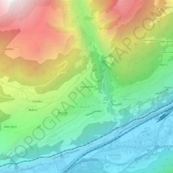
Name: Dichtuhüs topographic map, elevation, terrain.
Location: Dichtuhüs, Mund, Naters, Brig, Wallis, 3903, Switzerland (46.29988 7.92179 46.33988 7.96179)
Average elevation: 4,544 ft
Minimum elevation: 2,133 ft
Maximum elevation: 8,743 ft
Thank you for supporting this site ❤️
Make a donation
Make a donation
Gear up for your next adventure:
As an Amazon Associate, this site earns from qualifying purchases at no extra cost to you.