
Make a donation
Gear up for your next adventure:
As an Amazon Associate, this site earns from qualifying purchases at no extra cost to you.
Voëlvlei Lake topographic map
Click on the map to display elevation.
Make a donation
Gear up for your next adventure:
As an Amazon Associate, this site earns from qualifying purchases at no extra cost to you.
About this map
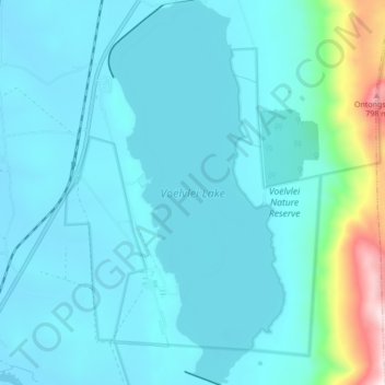
Name: Voëlvlei Lake topographic map, elevation, terrain.
Average elevation: 522 ft
Minimum elevation: 177 ft
Maximum elevation: 3,015 ft
Make a donation
Gear up for your next adventure:
As an Amazon Associate, this site earns from qualifying purchases at no extra cost to you.
Other topographic maps
Click on a map to view its topography, its elevation and its terrain.
Kromrivier
South Africa > Western Cape > Cape Winelands District Municipality > Drakenstein Local Municipality > Wellington
Average elevation: 492 ft
Wemmershoek Tafelberg
South Africa > Western Cape > Cape Winelands District Municipality > Drakenstein Local Municipality
Average elevation: 4,239 ft
Spitskop
South Africa > Western Cape > Cape Winelands District Municipality > Drakenstein Local Municipality
Average elevation: 2,277 ft
Simondium
South Africa > Western Cape > Cape Winelands District Municipality > Drakenstein Local Municipality
Average elevation: 505 ft
Make a donation
Gear up for your next adventure:
As an Amazon Associate, this site earns from qualifying purchases at no extra cost to you.
Berg en Dal
South Africa > Western Cape > Cape Winelands District Municipality > Drakenstein Local Municipality > Berg en Dal
Average elevation: 584 ft