
Make a donation
Gear up for your next adventure:
As an Amazon Associate, this site earns from qualifying purchases at no extra cost to you.
Velwano topographic map
Click on the map to display elevation.
Make a donation
Gear up for your next adventure:
As an Amazon Associate, this site earns from qualifying purchases at no extra cost to you.
About this map
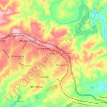
Name: Velwano topographic map, elevation, terrain.
Average elevation: 774 ft
Minimum elevation: 354 ft
Maximum elevation: 1,181 ft
Make a donation
Gear up for your next adventure:
As an Amazon Associate, this site earns from qualifying purchases at no extra cost to you.
Other topographic maps
Click on a map to view its topography, its elevation and its terrain.
Buffalo River
South Africa > Eastern Cape > Buffalo City Metropolitan Municipality > East London
Average elevation: 394 ft
Nahoon River
South Africa > Eastern Cape > Buffalo City Metropolitan Municipality > East London
Average elevation: 446 ft
Nahoon dam
South Africa > Eastern Cape > Buffalo City Metropolitan Municipality > Velwano
Average elevation: 623 ft
Buffalo City Ward 33
South Africa > Eastern Cape > Buffalo City Metropolitan Municipality
Average elevation: 751 ft
Make a donation
Gear up for your next adventure:
As an Amazon Associate, this site earns from qualifying purchases at no extra cost to you.