Geolocate

Piave topographic map

Click on the map to display elevation.

About this map

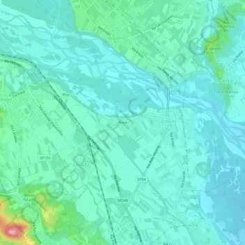
Name: Piave topographic map, elevation, terrain.

Location: Piave, Covolo, Pederobba, Treviso, Veneto, 31041, Italia (45.83476 11.99402 45.87476 12.03402)

Average elevation: 531 ft

Minimum elevation: 420 ft

Maximum elevation: 1,099 ft

Gear up for your next adventure:

🪶Wildlife Field Guides - Learn animal tracking and species ID
🎒Trail Energy Bars - High‑calorie bars for hiking energy
🧣Hiking Neck Gaiter - Multi‑use neck protection for outdoor weather
🛡️Bear Spray Outdoor - Protection in bear country hikes
🏕️Family Camping Gear - Essentials for group camping trips

As an Amazon Associate, this site earns from qualifying purchases at no extra cost to you.