
Make a donation
Gear up for your next adventure:
As an Amazon Associate, this site earns from qualifying purchases at no extra cost to you.
Gelinden topographic map
Click on the map to display elevation.
Make a donation
Gear up for your next adventure:
As an Amazon Associate, this site earns from qualifying purchases at no extra cost to you.
Gelinden
Gelinden ligt in Droog-Haspengouw nabij de vallei van de Herk, waar men het natuurgebied Overbroek vindt. De hoogte loopt op van ongeveer 50 meter nabij de Herk tot 102 meter in het zuiden.
Make a donation
Gear up for your next adventure:
As an Amazon Associate, this site earns from qualifying purchases at no extra cost to you.
About this map
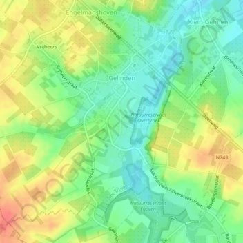
Name: Gelinden topographic map, elevation, terrain.
Location: Gelinden, Sint-Truiden, Hasselt, Limburg, België (50.74890 5.23372 50.77158 5.27609)
Average elevation: 282 ft
Minimum elevation: 203 ft
Maximum elevation: 374 ft
Make a donation
Gear up for your next adventure:
As an Amazon Associate, this site earns from qualifying purchases at no extra cost to you.
Other topographic maps
Click on a map to view its topography, its elevation and its terrain.
Make a donation
Gear up for your next adventure:
As an Amazon Associate, this site earns from qualifying purchases at no extra cost to you.
Make a donation
Gear up for your next adventure:
As an Amazon Associate, this site earns from qualifying purchases at no extra cost to you.