
Exmouth topographic map
Click on the map to display elevation.
About this map
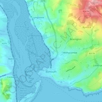
Name: Exmouth topographic map, elevation, terrain.
Location: Exmouth, East Devon, Devon, England, United Kingdom (50.60502 -3.43757 50.65575 -3.34921)
Average elevation: 92 ft
Minimum elevation: -10 ft
Maximum elevation: 535 ft
Other topographic maps
Click on a map to view its topography, its elevation and its terrain.
Weycroft
United Kingdom > England > Devon > East Devon > Axminster > Weycroft
Average elevation: 253 ft
Venn Ottery
United Kingdom > England > Devon > East Devon > Newton Poppleford
Average elevation: 233 ft
Southerton
United Kingdom > England > Devon > East Devon > Newton Poppleford
Average elevation: 233 ft
Cloakham
United Kingdom > England > Devon > East Devon > Axminster > Cloakham
Average elevation: 223 ft
Allercombe
United Kingdom > England > Devon > East Devon > Marsh Green > Allercombe
Average elevation: 295 ft