Drogheda topographic map
Interactive map
Click on the map to display elevation.
About this map
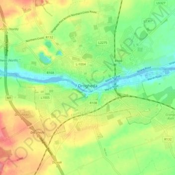
Name: Drogheda topographic map, elevation, terrain.
Location: Drogheda, County Louth, Leinster, Ireland (53.69442 -6.39292 53.73425 -6.29826)
Average elevation: 112 ft
Minimum elevation: -3 ft
Maximum elevation: 253 ft
Other topographic maps
Click on a map to view its topography, its elevation and its terrain.
Broadlough
Broadlough, Ardee Rural ED, The Municipal District of Ardee, County Louth, Leinster, Ireland
Average elevation: 112 ft
Collon
Collon, Collon ED, The Municipal District of Ardee, County Louth, Leinster, Ireland
Average elevation: 472 ft
Dunleer
Dunleer, The Municipal District of Ardee, County Louth, Leinster, Ireland
Average elevation: 131 ft
Ballinteskin
Ballinteskin, Drummullagh ED, The Municipal District of Dundalk, County Louth, Leinster, Ireland
Average elevation: 558 ft
Grattanstown
Grattanstown, Dysart ED, The Municipal District of Ardee, County Louth, Leinster, Ireland
Average elevation: 184 ft
Dundalk
Ireland > County Louth > Dundalk
Dundalk, The Municipal District of Dundalk, County Louth, Leinster, A91 RC44, Ireland
Average elevation: 52 ft
Clogherhead
Clogherhead, County Louth, Leinster, Ireland
Average elevation: 56 ft
Carlingford
Carlingford, County Louth, Leinster, Ireland
Average elevation: 276 ft
Rathcor
Rathcor, Rathcor ED, The Municipal District of Dundalk, County Louth, Leinster, Ireland
Average elevation: 72 ft
Drogheda
Ireland > County Louth > Drogheda
Drogheda, The Borough District of Drogheda, County Louth, Leinster, A92DKR0, Ireland
Average elevation: 125 ft
The Municipal District of Ardee
The Municipal District of Ardee, County Louth, Leinster, Ireland
Average elevation: 148 ft
Dundalk Poor Law Union
Dundalk Poor Law Union, County Louth, Leinster, Ireland
Average elevation: 243 ft
Drogheda Poor Law Union 1885
Drogheda Poor Law Union 1885, County Louth, Leinster, Ireland
Average elevation: 174 ft
Priest Town
Priest Town, Mullary ED, The Municipal District of Ardee, County Louth, Leinster, Ireland
Average elevation: 344 ft
Falmore
Falmore, Faughart ED, The Municipal District of Dundalk, County Louth, Leinster, Ireland
Average elevation: 102 ft
Dromiskin
Dromiskin, Dromiskin ED, The Municipal District of Dundalk, County Louth, Leinster, A91 RW01, Ireland
Average elevation: 26 ft
Brookville Park
Brookville Park, Fair Gate ED, The Borough District of Drogheda, County Louth, Leinster, Ireland
Average elevation: 85 ft
Carlingford
Ireland > County Louth > Carlingford
Carlingford, The Municipal District of Dundalk, County Louth, Leinster, A91 TRR6, Ireland
Average elevation: 276 ft
The Borough District of Drogheda
The Borough District of Drogheda, County Louth, Leinster, Ireland
Average elevation: 164 ft
Jenkinstown
Jenkinstown, Jenkinstown ED, The Municipal District of Dundalk, County Louth, Leinster, Ireland
Average elevation: 364 ft
Killeen
Killeen, Louth ED, The Municipal District of Ardee, County Louth, Leinster, Ireland
Average elevation: 115 ft
Collon
Ireland > County Louth > Collon
Collon, The Municipal District of Ardee, County Louth, Leinster, A92 K168, Ireland
Average elevation: 479 ft
Millgrange
Millgrange, Greenore ED, The Municipal District of Dundalk, County Louth, Leinster, Ireland
Average elevation: 69 ft
Lowrath North
Lowrath North, Louth ED, The Municipal District of Ardee, County Louth, Leinster, Ireland
Average elevation: 115 ft
Castletown
Castletown, Castletown ED, The Municipal District of Dundalk, County Louth, Leinster, Ireland
Average elevation: 46 ft
Monasterboice
Monasterboice, Monasterboice ED, The Borough District of Drogheda, County Louth, Leinster, Ireland
Average elevation: 361 ft
Greenmount
Greenmount, Castlebellingham ED, The Municipal District of Ardee, County Louth, Leinster, Ireland
Average elevation: 59 ft
Mountbagnall
Mountbagnall, Rathcor ED, The Municipal District of Dundalk, County Louth, Leinster, Ireland
Average elevation: 79 ft
Drumcashel
Drumcashel, Stabannan ED, The Municipal District of Ardee, County Louth, Leinster, Ireland
Average elevation: 82 ft
Marsh North
Marsh North, Dundalk Rural ED, The Municipal District of Dundalk, County Louth, Leinster, Ireland
Average elevation: 10 ft
Newtownstalaban
Newtownstalaban, St. Peter's ED, The Borough District of Drogheda, County Louth, Leinster, Ireland
Average elevation: 66 ft
Dromiskin
Ireland > County Louth > Dromiskin
Dromiskin, The Municipal District of Dundalk, County Louth, Leinster, A91 RW01, Ireland
Average elevation: 26 ft
Ballagan
Ballagan, Greenore ED, The Municipal District of Dundalk, County Louth, Leinster, Ireland
Average elevation: 30 ft
Mullincross
Mullincross, Castlebellingham ED, The Municipal District of Ardee, County Louth, Leinster, Ireland
Average elevation: 66 ft
Faughart
Faughart, The Municipal District of Dundalk, County Louth, Leinster, Ireland
Average elevation: 180 ft
Mullagharlin
Mullagharlin, Dundalk Rural ED, The Municipal District of Dundalk, County Louth, Leinster, Ireland
Average elevation: 56 ft
The Municipal District of Dundalk
The Municipal District of Dundalk, County Louth, Leinster, Ireland
Average elevation: 223 ft
Mullavally
Mullavally, Louth ED, The Municipal District of Ardee, County Louth, Leinster, Ireland
Average elevation: 112 ft
Tinure
Tinure, The Municipal District of Ardee, County Louth, Leinster, A92 V4Y2, Ireland
Average elevation: 328 ft