
Thank you for supporting this site ❤️
Make a donation
Make a donation
Gear up for your next adventure:
As an Amazon Associate, this site earns from qualifying purchases at no extra cost to you.
Ghazaouet topographic map
Click on the map to display elevation.
Thank you for supporting this site ❤️
Make a donation
Make a donation
Gear up for your next adventure:
As an Amazon Associate, this site earns from qualifying purchases at no extra cost to you.
About this map
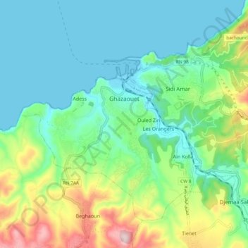
Name: Ghazaouet topographic map, elevation, terrain.
Location: Ghazaouet, Ghazaouet District, Tlemcen, Algeria (35.05621 -1.90250 35.11567 -1.80901)
Average elevation: 328 ft
Minimum elevation: -3 ft
Maximum elevation: 1,237 ft
Thank you for supporting this site ❤️
Make a donation
Make a donation
Gear up for your next adventure:
As an Amazon Associate, this site earns from qualifying purchases at no extra cost to you.