Geolocate

Argino topographic map

Click on the map to display elevation.

About this map

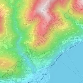
Name: Argino topographic map, elevation, terrain.

Location: Argino, Vercana, Como, Lombardia, 22013, Italia (46.15021 9.31377 46.19021 9.35377)

Average elevation: 1,932 ft

Minimum elevation: 646 ft

Maximum elevation: 4,154 ft

Gear up for your next adventure:

🔦LED Headlamp - Bright and durable LED headlamp for night navigation
🛠️Backpacking Tool Kit - Essential toolkit for outdoor repairs
🎒Waterproof Dry Bags - Keep your electronics and maps dry inside your pack
🎒Trail Energy Bars - High‑calorie bars for hiking energy
📱Solar Portable Charger - Solar power bank for charging devices off‑grid

As an Amazon Associate, this site earns from qualifying purchases at no extra cost to you.