
Make a donation
Gear up for your next adventure:
As an Amazon Associate, this site earns from qualifying purchases at no extra cost to you.
Kapama Game Reserve topographic map
Click on the map to display elevation.
Make a donation
Gear up for your next adventure:
As an Amazon Associate, this site earns from qualifying purchases at no extra cost to you.
About this map
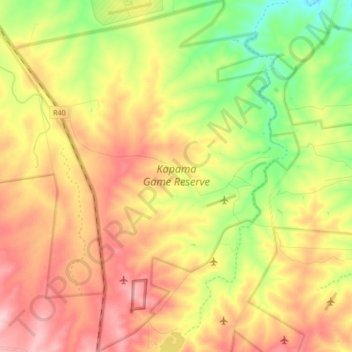
Name: Kapama Game Reserve topographic map, elevation, terrain.
Average elevation: 1,759 ft
Minimum elevation: 1,480 ft
Maximum elevation: 2,031 ft
Make a donation
Gear up for your next adventure:
As an Amazon Associate, this site earns from qualifying purchases at no extra cost to you.
Other topographic maps
Click on a map to view its topography, its elevation and its terrain.
Ga-Mamatlhola
South Africa > Limpopo > Mopani District Municipality > Maruleng Local Municipality
Average elevation: 1,955 ft
Legalameetse
South Africa > Limpopo > Mopani District Municipality > Maruleng Local Municipality
Average elevation: 3,911 ft
Selati Nature Reserve
South Africa > Limpopo > Mopani District Municipality > Maruleng Local Municipality
Average elevation: 1,919 ft