
Thank you for supporting this site ❤️
Make a donation
Make a donation
Gear up for your next adventure:
As an Amazon Associate, this site earns from qualifying purchases at no extra cost to you.
Corujeira topographic map
Click on the map to display elevation.
Thank you for supporting this site ❤️
Make a donation
Make a donation
Gear up for your next adventure:
As an Amazon Associate, this site earns from qualifying purchases at no extra cost to you.
About this map
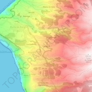
Name: Corujeira topographic map, elevation, terrain.
Location: Corujeira, Ponta do Pargo, Calheta, Madeira, 9385, Portugal (32.78478 -17.25351 32.82478 -17.21351)
Average elevation: 1,841 ft
Minimum elevation: -3 ft
Maximum elevation: 3,241 ft
Thank you for supporting this site ❤️
Make a donation
Make a donation
Gear up for your next adventure:
As an Amazon Associate, this site earns from qualifying purchases at no extra cost to you.