
Sankt Sebastian topographic map
Click on the map to display elevation.
Sankt Sebastian
Im Zuge der Industrialisierung erhielt St. Sebastian Anschluss an moderne Errungenschaften: Seit 1913 fährt die erste Motorfähre zwischen St. Sebastian und Bendorf und seit 1918 gibt es elektrisches Licht im Ort. Im Jahr 1927 gab es das erste Leitungswasser in St. Sebastian. Die Qualität des Grundwassers ist derart hoch, dass große Teile der Gemarkungsflächen noch heute Trinkwasserschutzgebiet sind. Aus den Brunnen in der Gemarkung St. Sebastian wird das Wasser bis in den Hunsrück (ehem. Wasserversorgung Rheinhöhen mit Wasserwerk St. Sebastian seit 1972, heute RheinHunsrück Wasser) und in die Region Koblenz (Wasserwerk Koblenz/Weißenthurm) gepumpt.
About this map
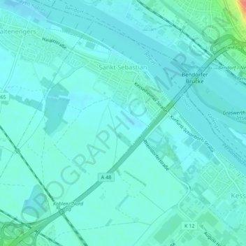
Name: Sankt Sebastian topographic map, elevation, terrain.
Average elevation: 223 ft
Minimum elevation: 190 ft
Maximum elevation: 417 ft
Other topographic maps
Click on a map to view its topography, its elevation and its terrain.
Pfaffenheck
Deutschland > Rheinland-Pfalz > Landkreis Mayen-Koblenz > Pfaffenheck
Average elevation: 1,191 ft
Hausen
Deutschland > Rheinland-Pfalz > Landkreis Mayen-Koblenz > Mayen
Der Ursprung der katholischen Kirche St. Silvester ist Ende des 12. Jahrhunderts anzunehmen; es war eine zweischiffige Pfeilerbasilika mit halbrundem Chor. Ein Pfarrer von „Huyssen“ ist um 1330 erstmals genannt. In der Zeit um 1330 bis 1340 wurde der romanische Chor niedergelegt, das Kirchenschiff…
Average elevation: 797 ft
Aussichtspunkt auf Laacher See (wenn Bäume ohne Laub)
Deutschland > Rheinland-Pfalz > Landkreis Mayen-Koblenz > Kruft
Average elevation: 1,060 ft
Löwenburg
Deutschland > Rheinland-Pfalz > Landkreis Mayen-Koblenz > Monreal
Gleich mit zwei Halsgräben ist die Hauptburg gesichert: Ein bogenförmiger schützt sie zum höher gelegenen Berghang im Nordwesten, ein weiterer trennt sie von der östlichen Vorburg, von der nur noch wenige Reste erhalten sind.
Average elevation: 1,168 ft
Kürrenberg
Deutschland > Rheinland-Pfalz > Landkreis Mayen-Koblenz > Mayen
Average elevation: 1,385 ft
Hünenfeld
Deutschland > Rheinland-Pfalz > Landkreis Mayen-Koblenz > Rhens > Hünenfeld
Average elevation: 1,099 ft
Waldesch
Deutschland > Rheinland-Pfalz > Landkreis Mayen-Koblenz > Waldesch > Waldesch
Die alte Römerstraße von Koblenz nach Trier, der die heutige Hunsrückhöhenstraße (B 327) auf langen Wegstücken folgt, führt direkt am Ort vorbei.
Average elevation: 1,024 ft
Schloss Bürresheim
Deutschland > Rheinland-Pfalz > Landkreis Mayen-Koblenz > Sankt Johann
Average elevation: 1,302 ft
Mariaroth
Deutschland > Rheinland-Pfalz > Landkreis Mayen-Koblenz
Der Ortsteil liegt rd. 5 km oberhalb der Mosel an der K69 zwischen Waldesch und Dieblich am Hang der Hunsrückhöhen.
Average elevation: 912 ft
Namedy
Deutschland > Rheinland-Pfalz > Landkreis Mayen-Koblenz > Andernach
Unter besonderem Schutz steht die frühere Rheinaueninsel Namedyer Werth (seit etwa 1857 Halbinsel im Zuge der Rheinbegradigung), die seit 1985 ein bedeutendes Vogelschutzgebiet ist. Dort um 1903 ein Kaltwassergeysir erbohrt, dessen Kohlensäure und Mineralwasser unter dem Namen „Namedyer Sprudel“…
Average elevation: 604 ft
Feller Hof
Deutschland > Rheinland-Pfalz > Landkreis Mayen-Koblenz > Niederfell
Average elevation: 676 ft
Nassheck
Deutschland > Rheinland-Pfalz > Landkreis Mayen-Koblenz > Dieblich
Average elevation: 1,188 ft
Michelberg
Deutschland > Rheinland-Pfalz > Landkreis Mayen-Koblenz > Ochtendung
Average elevation: 607 ft
Rheinanlagen
Deutschland > Rheinland-Pfalz > Landkreis Mayen-Koblenz > Andernach
Average elevation: 397 ft
Burg Eltz
Deutschland > Rheinland-Pfalz > Landkreis Mayen-Koblenz > Wierschem
Die Burg Eltz ist eine Höhenburg aus dem 12. Jahrhundert und eine der bekanntesten ihrer Art in Deutschland. Sie liegt auf 129 m ü. NHN im Tal der Elz, einem linken Nebenfluss der Mosel, in der Gemarkung der Ortsgemeinde Wierschem in Rheinland-Pfalz. Seit mehr als 800 Jahren ist das Bauwerk im Besitz der…
Average elevation: 719 ft
Tongrube Hüttwohl
Deutschland > Rheinland-Pfalz > Landkreis Mayen-Koblenz > Bendorf
Average elevation: 804 ft
Geysir Andernach
Deutschland > Rheinland-Pfalz > Landkreis Mayen-Koblenz > Andernach > Namedy
Der Geysir Andernach (ursprünglich: Namedyer Sprudel) ist mit etwa 50 bis 60 Metern Auswurfhöhe der höchste Kaltwassergeysir der Erde. Er befindet sich auf dem Namedyer Werth, einer Halbinsel im Rhein bei Andernach im rheinland-pfälzischen Landkreis Mayen-Koblenz, und wurde 1903 erstmals erbohrt.
Average elevation: 469 ft
Eschbach
Deutschland > Rheinland-Pfalz > Landkreis Mayen-Koblenz > Döttingen > Eschbach
Average elevation: 1,795 ft
Fernblick 90km
Deutschland > Rheinland-Pfalz > Landkreis Mayen-Koblenz > Ettringen
Average elevation: 1,362 ft
Miesenheim
Deutschland > Rheinland-Pfalz > Landkreis Mayen-Koblenz > Andernach
Average elevation: 394 ft
Wüstenhof
Deutschland > Rheinland-Pfalz > Landkreis Mayen-Koblenz > Weitersburg
Average elevation: 512 ft
Korbsmühle
Deutschland > Rheinland-Pfalz > Landkreis Mayen-Koblenz > Ochtendung
Average elevation: 650 ft