
Make a donation
Gear up for your next adventure:
As an Amazon Associate, this site earns from qualifying purchases at no extra cost to you.
San Pedro Soloma topographic map
Click on the map to display elevation.
Make a donation
Gear up for your next adventure:
As an Amazon Associate, this site earns from qualifying purchases at no extra cost to you.
About this map
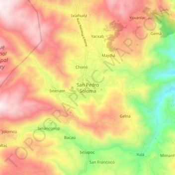
Name: San Pedro Soloma topographic map, elevation, terrain.
Location: San Pedro Soloma, Huehuetenango, Guatemala (15.61815 -91.47014 15.69815 -91.39014)
Average elevation: 7,795 ft
Minimum elevation: 5,607 ft
Maximum elevation: 9,636 ft
Make a donation
Gear up for your next adventure:
As an Amazon Associate, this site earns from qualifying purchases at no extra cost to you.
Other topographic maps
Click on a map to view its topography, its elevation and its terrain.
Make a donation
Gear up for your next adventure:
As an Amazon Associate, this site earns from qualifying purchases at no extra cost to you.
Make a donation
Gear up for your next adventure:
As an Amazon Associate, this site earns from qualifying purchases at no extra cost to you.
Campus Universidad Mariano Gálvez
Guatemala > Huehuetenango > Municipio de Huenuetenango > Huehuetenango
Average elevation: 6,175 ft
Make a donation
Gear up for your next adventure:
As an Amazon Associate, this site earns from qualifying purchases at no extra cost to you.
Campus Universidad Mariano Gálvez
Guatemala > Huehuetenango > Municipio de Huenuetenango > Huehuetenango
Average elevation: 6,175 ft
Make a donation
Gear up for your next adventure:
As an Amazon Associate, this site earns from qualifying purchases at no extra cost to you.