
Make a donation
Gear up for your next adventure:
As an Amazon Associate, this site earns from qualifying purchases at no extra cost to you.
Tamworth topographic map
Click on the map to display elevation.
Make a donation
Gear up for your next adventure:
As an Amazon Associate, this site earns from qualifying purchases at no extra cost to you.
About this map
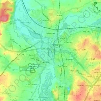
Name: Tamworth topographic map, elevation, terrain.
Location: Tamworth, Staffordshire, England, United Kingdom (52.58867 -1.73582 52.65750 -1.63293)
Average elevation: 249 ft
Minimum elevation: 154 ft
Maximum elevation: 427 ft
Make a donation
Gear up for your next adventure:
As an Amazon Associate, this site earns from qualifying purchases at no extra cost to you.
Other topographic maps
Click on a map to view its topography, its elevation and its terrain.
Brown Lees Rec
United Kingdom > England > Staffordshire > Staffordshire Moorlands > Biddulph
Average elevation: 689 ft
Chasewater
United Kingdom > England > Staffordshire > Lichfield > Burntwood > Chasetown
Average elevation: 509 ft