
Thank you for supporting this site ❤️
Make a donation
Make a donation
Gear up for your next adventure:
As an Amazon Associate, this site earns from qualifying purchases at no extra cost to you.
Gurjal topographic map
Click on the map to display elevation.
Thank you for supporting this site ❤️
Make a donation
Make a donation
Gear up for your next adventure:
As an Amazon Associate, this site earns from qualifying purchases at no extra cost to you.
About this map
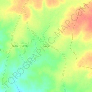
Name: Gurjal topographic map, elevation, terrain.
Location: Gurjal, Gandhari mandal, Kamareddy District, Telangana, India (18.33814 78.12132 18.37814 78.16132)
Average elevation: 1,781 ft
Minimum elevation: 1,683 ft
Maximum elevation: 1,873 ft
Thank you for supporting this site ❤️
Make a donation
Make a donation
Gear up for your next adventure:
As an Amazon Associate, this site earns from qualifying purchases at no extra cost to you.