
Make a donation
Gear up for your next adventure:
As an Amazon Associate, this site earns from qualifying purchases at no extra cost to you.
Curado topographic map
Click on the map to display elevation.
Make a donation
Gear up for your next adventure:
As an Amazon Associate, this site earns from qualifying purchases at no extra cost to you.
About this map
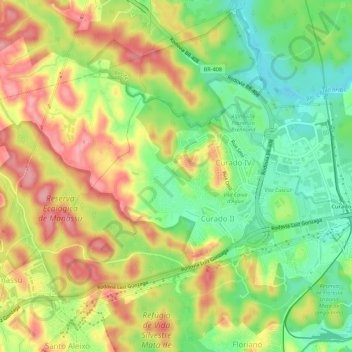
Name: Curado topographic map, elevation, terrain.
Average elevation: 203 ft
Minimum elevation: -13 ft
Maximum elevation: 423 ft
Make a donation
Gear up for your next adventure:
As an Amazon Associate, this site earns from qualifying purchases at no extra cost to you.
Other topographic maps
Click on a map to view its topography, its elevation and its terrain.
Lagoa Azul
Brasil > Pernambuco > Região Metropolitana do Recife > Jaboatão dos Guararapes
Average elevation: 141 ft
Rio Jordão
Brasil > Pernambuco > Região Metropolitana do Recife > Jaboatão dos Guararapes
Average elevation: 102 ft
Rio das Velhas
Brasil > Pernambuco > Região Metropolitana do Recife > Jaboatão dos Guararapes
Average elevation: 20 ft
Rio Jaboatão
Brasil > Pernambuco > Região Metropolitana do Recife > Jaboatão dos Guararapes
Average elevation: 253 ft
Make a donation
Gear up for your next adventure:
As an Amazon Associate, this site earns from qualifying purchases at no extra cost to you.
Portal dos Prazeres
Brasil > Pernambuco > Região Metropolitana do Recife > Jaboatão dos Guararapes > Portal dos Prazeres
Average elevation: 59 ft
Praia de Piedade
Brasil > Pernambuco > Região Metropolitana do Recife > Jaboatão dos Guararapes
Average elevation: 16 ft
Guruji
Brasil > Pernambuco > Região Metropolitana do Recife > Jaboatão dos Guararapes
Average elevation: 13 ft
Rio Duas Unas
Brasil > Pernambuco > Região Metropolitana do Recife > Jaboatão dos Guararapes > Vila Marielle Franco
Average elevation: 249 ft
Make a donation
Gear up for your next adventure:
As an Amazon Associate, this site earns from qualifying purchases at no extra cost to you.