Geolocate

Semberg topographic map

Click on the map to display elevation.

About this map

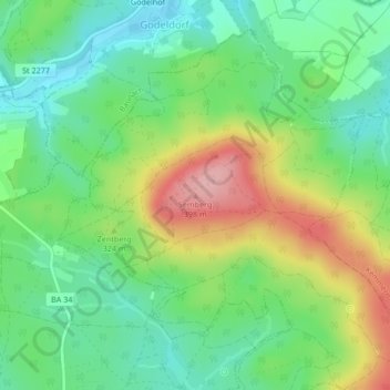
Name: Semberg topographic map, elevation, terrain.

Location: Semberg, Landkreis Bamberg, Bayern, 96148, Deutschland (49.96320 10.82745 49.96330 10.82755)

Average elevation: 1,020 ft

Minimum elevation: 833 ft

Maximum elevation: 1,335 ft

Gear up for your next adventure:

🌡️Portable Weather Meter - Track weather conditions on the trail
🕶️Glacier Sunglasses - Side shields to protect eyes from high-altitude snow glare
🪶LED Camping Lantern - Bright lantern for camp lighting
🏕️Tent Footprint - Protect your tent base from wear
🖼️Topo Map Wall Art - Decorative topographic prints of famous peaks and regions

As an Amazon Associate, this site earns from qualifying purchases at no extra cost to you.