
Make a donation
Gear up for your next adventure:
As an Amazon Associate, this site earns from qualifying purchases at no extra cost to you.
Laapersveld topographic map
Click on the map to display elevation.
Make a donation
Gear up for your next adventure:
As an Amazon Associate, this site earns from qualifying purchases at no extra cost to you.
About this map
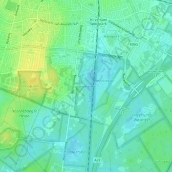
Name: Laapersveld topographic map, elevation, terrain.
Location: Laapersveld, Hilversum, Noord-Holland, Nederland (52.20002 5.17992 52.21063 5.18655)
Average elevation: 26 ft
Minimum elevation: -3 ft
Maximum elevation: 69 ft
Make a donation
Gear up for your next adventure:
As an Amazon Associate, this site earns from qualifying purchases at no extra cost to you.
Other topographic maps
Click on a map to view its topography, its elevation and its terrain.
Hoorneboegse Heide
Nederland > Noord-Holland > Hilversum
De Hoorneboegse heide is een archeologisch monument. Er bevinden zich op de heide 15-20 grafheuvels. Ook zijn er recent raatakkers ontdekt. De ontdekking hiervan is beschreven in een artikel in Archeologica Naerdincklant. Met het hoogtebestand van Nederland (AHN2) zijn de lokale hoogteverschillen berekend.…
Average elevation: 23 ft
Zwarte Berg
Nederland > Noord-Holland > Hilversum
De Zwarte Berg is een natuurgebied ten zuidoosten van de Hoorneboegse Heide bij Hilversum. Het is een bosgebied tussen de Hoorneboegse Heide en Hollandsche Rading, aan de westzijde van de Utrechtseweg (N227). De gelijknamige heuvel heeft een hoogte van ca. 16 meter boven NAP. Bij de Zwarte Berg loopt het…
Average elevation: 16 ft