
Nantgwynant topographic map
Interactive map
Click on the map to display elevation.
About this map
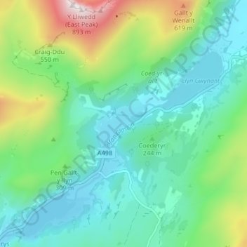
Name: Nantgwynant topographic map, elevation, terrain.
Average elevation: 866 ft
Minimum elevation: 171 ft
Maximum elevation: 2,864 ft
Other topographic maps
Click on a map to view its topography, its elevation and its terrain.
Snowdonia
United Kingdom > Wales > Gwynedd > Beddgelert
Snowdonia, Beddgelert, Gwynedd, Wales, LL55 4UL, United Kingdom
Average elevation: 2,297 ft
Llyn Gwynant
United Kingdom > Wales > Gwynedd > Beddgelert > Nantgwynant
Llyn Gwynant, Nantgwynant, Beddgelert, Gwynedd, Wales, United Kingdom
Average elevation: 804 ft