
Thank you for supporting this site ❤️
Make a donation
Make a donation
Gear up for your next adventure:
As an Amazon Associate, this site earns from qualifying purchases at no extra cost to you.
Šmarje topographic map
Click on the map to display elevation.
Thank you for supporting this site ❤️
Make a donation
Make a donation
Gear up for your next adventure:
As an Amazon Associate, this site earns from qualifying purchases at no extra cost to you.
About this map
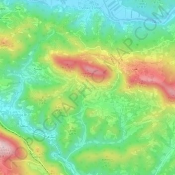
Name: Šmarje topographic map, elevation, terrain.
Location: Šmarje, Ajdovščina, 5263, Slovenia (45.82932 13.83009 45.86932 13.87009)
Average elevation: 659 ft
Minimum elevation: 240 ft
Maximum elevation: 1,378 ft
Thank you for supporting this site ❤️
Make a donation
Make a donation
Gear up for your next adventure:
As an Amazon Associate, this site earns from qualifying purchases at no extra cost to you.