Geolocate

Weingarten topographic map

Click on the map to display elevation.

About this map

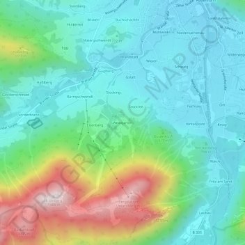
Name: Weingarten topographic map, elevation, terrain.

Location: Weingarten, Ruhpolding, Landkreis Traunstein, Bayern, 83324, Deutschland (47.72081 12.61803 47.76081 12.65803)

Average elevation: 2,825 ft

Minimum elevation: 2,133 ft

Maximum elevation: 4,764 ft

Other topographic maps

Click on a map to view its topography, its elevation and its terrain.

Fischbach

Deutschland > Bayern > Landkreis Traunstein > Ruhpolding > Laubau

Average elevation: 2,907 ft

Taubensee

Deutschland > Bayern > Landkreis Traunstein > Ruhpolding > Ramsler

Average elevation: 2,913 ft

Gear up for your next adventure:

🎒Trail Energy Bars - High‑calorie bars for hiking energy
🧴Hand Sanitizer - Keep hands clean while hiking
🌐World Map Poster - Decorative world maps with topographic info
🧤Hiking Gloves - Protective gloves for rugged trails
🥾Women's Hiking Boots - Top-rated trail boots with ankle support and superior grip

As an Amazon Associate, this site earns from qualifying purchases at no extra cost to you.