
Chicopee topographic map
Click on the map to display elevation.
Chicopee
Willimansett, and portions of the Center and Falls are on low land, with Aldenville, Fairview, Westover, and the Burnett Road neighborhoods on an elevated plateau. At 288 feet, the highest elevation in the city is on Old Lyman Road, in the Fairview section.
About this map
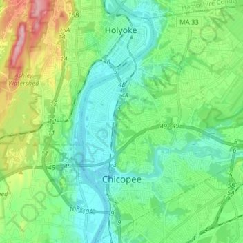
Name: Chicopee topographic map, elevation, terrain.
Location: Chicopee, Hampden County, Massachusetts, United States (42.12377 -72.62863 42.21873 -72.51391)
Average elevation: 220 ft
Minimum elevation: 36 ft
Maximum elevation: 745 ft
Hampden County trails, hiking, mountain biking, running and outdoor activities
Other topographic maps
Click on a map to view its topography, its elevation and its terrain.
Mittineague
United States > Massachusetts > Hampden County > West Springfield
Average elevation: 161 ft
Duckville
United States > Massachusetts > Hampden County > Palmer > Bondsville
Average elevation: 440 ft
Meadowbrook Green
United States > Massachusetts > Hampden County > Palmer > Thorndike
Average elevation: 453 ft
Palmer Green Estates
United States > Massachusetts > Hampden County > Palmer
Average elevation: 459 ft
Victory Lake Dam
United States > Massachusetts > Hampden County > Camp Spruce Hill
Average elevation: 1,040 ft