Geolocate

Busoba topographic map

Interactive map

Click on the map to display elevation.

About this map

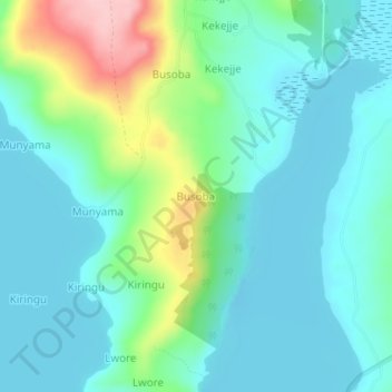
Name: Busoba topographic map, elevation, terrain.

Location: Busoba, Buvuma, Central Region, Uganda (0.11325 33.27416 0.15325 33.31416)

Average elevation: 3,852 ft

Minimum elevation: 3,711 ft

Maximum elevation: 4,327 ft

Other topographic maps

Click on a map to view its topography, its elevation and its terrain.

Luwero

Uganda > Buvuma

Luwero, Buvuma, Central Region, Uganda

Average elevation: 3,720 ft

Buvuma

Uganda > Buvuma

Buvuma, Central Region, Uganda

Average elevation: 3,740 ft