
Make a donation
Gear up for your next adventure:
As an Amazon Associate, this site earns from qualifying purchases at no extra cost to you.
Wanrong topographic map
Click on the map to display elevation.
Make a donation
Gear up for your next adventure:
As an Amazon Associate, this site earns from qualifying purchases at no extra cost to you.
Wanrong
The elevation and climate changes greatly with the mountains of Central Range, and the adverse elevation is about 600 m. The main inhabitants are Truku people, Bunun people and Atayal people of the Taiwanese aborigines, and most economic activity is agriculture, which located in the small plain near Fenglin Township. The abundant resources of tourism has not been developed.
Make a donation
Gear up for your next adventure:
As an Amazon Associate, this site earns from qualifying purchases at no extra cost to you.
About this map
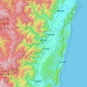
Name: Wanrong topographic map, elevation, terrain.
Location: Wanrong, Hualien County, 979, Taiwan (23.46606 121.20464 23.92651 121.45329)
Average elevation: 2,959 ft
Minimum elevation: 0 ft
Maximum elevation: 11,237 ft
Make a donation
Gear up for your next adventure:
As an Amazon Associate, this site earns from qualifying purchases at no extra cost to you.
Other topographic maps
Click on a map to view its topography, its elevation and its terrain.