
Make a donation
Gear up for your next adventure:
As an Amazon Associate, this site earns from qualifying purchases at no extra cost to you.
Newkirk topographic map
Click on the map to display elevation.
Make a donation
Gear up for your next adventure:
As an Amazon Associate, this site earns from qualifying purchases at no extra cost to you.
Newkirk
Newkirk's elevation is 1,152 feet (351 m). It is on mostly flat terrain with no large watercourses nearby, and at the boundary between two ecoregions: the Central Great Plains and the Flint Hills. West of the town on the Great Plains, the countryside is rich agricultural land, especially for wheat, soybeans, and cattle. East of town, the Flint Hills' terrain is more rugged and rocky and is primarily used for cattle ranching. Natural vegetation is mostly prairie, but stream valleys often have forests of cottonwood, oak, elm, ash, pecan, sycamore, and other species. Scrub oak and red cedar dot hillsides. Wildlife is abundant, including whitetail deer, turkey, bobwhite quail, coyote, bobcat, and waterfowl. A cougar attack on a person seven miles (11 km) east of Newkirk was reported in 2002.
Make a donation
Gear up for your next adventure:
As an Amazon Associate, this site earns from qualifying purchases at no extra cost to you.
About this map
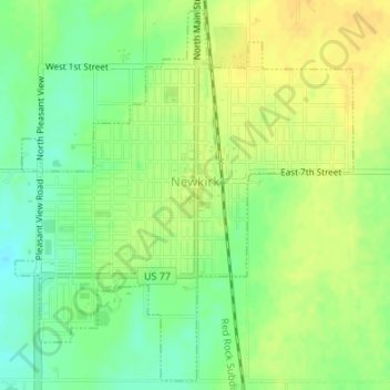
Name: Newkirk topographic map, elevation, terrain.
Location: Newkirk, Kay County, Oklahoma, 74647, United States (36.86857 -97.06925 36.89420 -97.04001)
Average elevation: 1,148 ft
Minimum elevation: 1,099 ft
Maximum elevation: 1,184 ft
Kay County trails, hiking, mountain biking, running and outdoor activities
Make a donation
Gear up for your next adventure:
As an Amazon Associate, this site earns from qualifying purchases at no extra cost to you.
Other topographic maps
Click on a map to view its topography, its elevation and its terrain.