
Thank you for supporting this site ❤️
Make a donation
Make a donation
Gear up for your next adventure:
As an Amazon Associate, this site earns from qualifying purchases at no extra cost to you.
Bourré topographic map
Click on the map to display elevation.
Thank you for supporting this site ❤️
Make a donation
Make a donation
Gear up for your next adventure:
As an Amazon Associate, this site earns from qualifying purchases at no extra cost to you.
About this map
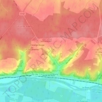
Name: Bourré topographic map, elevation, terrain.
Average elevation: 354 ft
Minimum elevation: 174 ft
Maximum elevation: 459 ft
Thank you for supporting this site ❤️
Make a donation
Make a donation
Gear up for your next adventure:
As an Amazon Associate, this site earns from qualifying purchases at no extra cost to you.
Other topographic maps
Click on a map to view its topography, its elevation and its terrain.
Rigaudon
France > Centre-Val de Loire > Loir-et-Cher > Montrichard Val de Cher
Average elevation: 318 ft
La Batardière
France > Centre-Val de Loire > Loir-et-Cher > Montrichard Val de Cher
Average elevation: 325 ft