
Make a donation
Gear up for your next adventure:
As an Amazon Associate, this site earns from qualifying purchases at no extra cost to you.
Saint-Genis-Pouilly topographic map
Click on the map to display elevation.
Make a donation
Gear up for your next adventure:
As an Amazon Associate, this site earns from qualifying purchases at no extra cost to you.
Saint-Genis-Pouilly
Saint-Genis-Pouilly is composed of two market towns (Saint-Genis and Pouilly) and two hamlets (Pregnin and Flies). The two market towns have both continued to expand and now practically merge into one, however the two hamlets still remain separate from each other and from the two towns. The elevation of the commune varies from 419 m (at the extreme south of the commune, to the confluence of the rivers Allondon and Nant de l'Ecra) to 502 m (at the extreme north of the commune, in the village of Flies). The commune is situated at the limit between the plains surrounding Geneva and the first foothills of the Jura. As indicated on the map opposite, the communes surrounding Saint-Genis-Pouilly are: Thoiry, Sergy, Crozet, Chevry, Prévessin-Moëns and Satigny (Swiss).
Make a donation
Gear up for your next adventure:
As an Amazon Associate, this site earns from qualifying purchases at no extra cost to you.
About this map
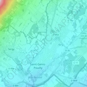
Name: Saint-Genis-Pouilly topographic map, elevation, terrain.
Average elevation: 1,565 ft
Minimum elevation: 1,394 ft
Maximum elevation: 2,989 ft
Make a donation
Gear up for your next adventure:
As an Amazon Associate, this site earns from qualifying purchases at no extra cost to you.