Geolocate
👉 Easily get elevation data in JSON, GeoTIFF and KML formats using Elevation API
Thank you for supporting this site ❤️
Make a donation

Hadstock topographic map

Click on the map to display elevation.

About this map

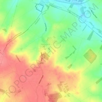
Name: Hadstock topographic map, elevation, terrain.

Location: Hadstock, Uttlesford, Essex, England, United Kingdom (52.06310 0.25186 52.09263 0.30505)

Average elevation: 266 ft

Minimum elevation: 131 ft

Maximum elevation: 390 ft

Gear up for your next adventure:

⛑️Personal Locator Beacon - Safety beacon for emergencies
Camping Coffee Makers - Enjoy premium coffee at the summit or campsite
🦶Carbon Trekking Poles - Reduce knee impact on steep descents with ultra-light poles
💧Water Filtration Bottles - Safely drink from streams and lakes while exploring
🪑Ultralight Camp Chairs - Portable seating for resting after a long day of mapping

As an Amazon Associate, this site earns from qualifying purchases at no extra cost to you.