Geolocate

Orielton topographic map

Click on the map to display elevation.

About this map

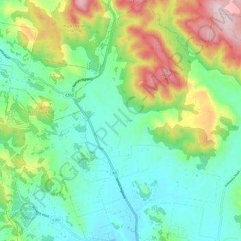
Name: Orielton topographic map, elevation, terrain.

Location: Orielton, Hobart, Sorell, Tasmania, Australia (-42.76030 147.46663 -42.67535 147.58174)

Average elevation: 486 ft

Minimum elevation: 16 ft

Maximum elevation: 1,526 ft

Other topographic maps

Click on a map to view its topography, its elevation and its terrain.

Selfs Point

Australia > Tasmania > Hobart

Average elevation: 56 ft

Waterworks Reserve

Australia > Tasmania > Hobart

Average elevation: 787 ft

James Austin Park

Australia > Tasmania > Hobart

Average elevation: 82 ft

Perrins Ridge

Australia > Tasmania > Hobart

Average elevation: 1,532 ft

Cartwright Point

Australia > Tasmania > Hobart

Average elevation: 194 ft

Mount Direction

Australia > Tasmania > Hobart

Average elevation: 545 ft

Glebe Hill

Australia > Tasmania > Hobart

Average elevation: 217 ft

Knocklofty

Australia > Tasmania > Hobart

Average elevation: 607 ft

Snug Falls

Australia > Tasmania > Hobart > Snug

Average elevation: 1,102 ft

Tolosa Park

Australia > Tasmania > Hobart

Average elevation: 597 ft

Glenrose Park

Australia > Tasmania > Hobart

Average elevation: 594 ft

Gear up for your next adventure:

🗺️Topographic Maps - Detailed topo maps for hiking, exploring and outdoor navigation
🚑Emergency Bivvies - Heat-reflective sleeping bags for survival situations
🧯Portable Fire Pit - Compact fire pit for camping spots
🔥Fast-Boil Camping Stoves - Efficient cooking systems for quick trail meals
☀️Outdoor Sunscreen - High protection sunscreen for outdoor activities

As an Amazon Associate, this site earns from qualifying purchases at no extra cost to you.