
Thank you for supporting this site ❤️
Make a donation
Make a donation
Gear up for your next adventure:
As an Amazon Associate, this site earns from qualifying purchases at no extra cost to you.
Lwambogo topographic map
Click on the map to display elevation.
Thank you for supporting this site ❤️
Make a donation
Make a donation
Gear up for your next adventure:
As an Amazon Associate, this site earns from qualifying purchases at no extra cost to you.
About this map
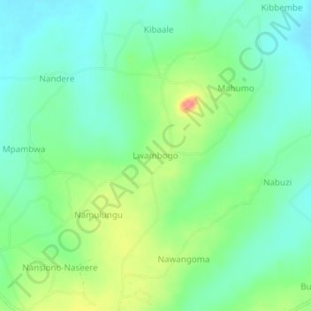
Name: Lwambogo topographic map, elevation, terrain.
Location: Lwambogo, Kaliro, Eastern Region, Uganda (1.10430 33.53732 1.14430 33.57732)
Average elevation: 3,481 ft
Minimum elevation: 3,406 ft
Maximum elevation: 3,638 ft
Thank you for supporting this site ❤️
Make a donation
Make a donation
Gear up for your next adventure:
As an Amazon Associate, this site earns from qualifying purchases at no extra cost to you.