
Thank you for supporting this site ❤️
Make a donation
Make a donation
Gear up for your next adventure:
As an Amazon Associate, this site earns from qualifying purchases at no extra cost to you.
Fiifhuzen topographic map
Click on the map to display elevation.
Thank you for supporting this site ❤️
Make a donation
Make a donation
Gear up for your next adventure:
As an Amazon Associate, this site earns from qualifying purchases at no extra cost to you.
Fiifhuzen
De buurtschap is ontstaan tussen 1915 en 1920 toen er een vijftal huizen werden neergezet. In 1970 is de plaatsnaam voor het eerst zichtbaar op de topografische kaarten.
Thank you for supporting this site ❤️
Make a donation
Make a donation
Gear up for your next adventure:
As an Amazon Associate, this site earns from qualifying purchases at no extra cost to you.
About this map
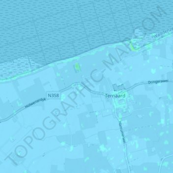
Name: Fiifhuzen topographic map, elevation, terrain.
Average elevation: -3 ft
Minimum elevation: -13 ft
Maximum elevation: 13 ft
Thank you for supporting this site ❤️
Make a donation
Make a donation
Gear up for your next adventure:
As an Amazon Associate, this site earns from qualifying purchases at no extra cost to you.