
Make a donation
Gear up for your next adventure:
As an Amazon Associate, this site earns from qualifying purchases at no extra cost to you.
Maxsee topographic map
Click on the map to display elevation.
Make a donation
Gear up for your next adventure:
As an Amazon Associate, this site earns from qualifying purchases at no extra cost to you.
Maxsee
Laut Datenerhebung des Instituts für angewandte Gewässerökologie Brandenburg aus dem Jahr 2001 ergeben sich folgende topographische, morphometrische und limnologische Werte für den Maxsee: die maximale Tiefe des Gewässers beträgt vier, die mittlere Tiefe rund zwei Meter. Der von Nordost nach Südwest langgestreckte schmale See hat eine maximale Längsausdehnung von 1560 und eine maximale Breite von 480 Metern und beschreibt im südlichen Bereich einen Bogen nach Westen. Seine Fläche beträgt 68 Hektar. Die theoretische Epilimniontiefe (Zepi), definiert als die erwärmte obere durchmischte Wassersäule mit relativ homogener Temperaturverteilung während der Sommerstagnation, beträgt 5,8 Meter. Der Tiefengradient (F) liegt bei 0,7.
Make a donation
Gear up for your next adventure:
As an Amazon Associate, this site earns from qualifying purchases at no extra cost to you.
About this map
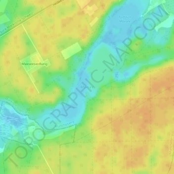
Name: Maxsee topographic map, elevation, terrain.
Average elevation: 171 ft
Minimum elevation: 115 ft
Maximum elevation: 217 ft
Make a donation
Gear up for your next adventure:
As an Amazon Associate, this site earns from qualifying purchases at no extra cost to you.