
Haikou topographic map
Interactive map
Click on the map to display elevation.
About this map
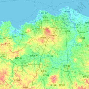
Name: Haikou topographic map, elevation, terrain.
Location: Haikou, Hainan, Chine (19.52594 110.10308 20.13217 110.70807)
Average elevation: 131 ft
Minimum elevation: -10 ft
Maximum elevation: 666 ft
Other topographic maps
Click on a map to view its topography, its elevation and its terrain.
海口湾
Chine > Hainan > District de Xiuying
海口湾, District de Xiuying, Haikou, Hainan, 570125, Chine
Average elevation: 0 ft
Xian autonome li de Ledong
Xian autonome li de Ledong, Hainan, Chine
Average elevation: 1,079 ft