
Make a donation
Gear up for your next adventure:
As an Amazon Associate, this site earns from qualifying purchases at no extra cost to you.
Brusnica topographic map
Click on the map to display elevation.
Make a donation
Gear up for your next adventure:
As an Amazon Associate, this site earns from qualifying purchases at no extra cost to you.
Brusnica
The municipality lies at an altitude of 199 metres and covers an area of 14.283 km². It has a population of about 415 people. The village has a significant Rusyn minority (32%) and smaller Romani minority (2%), along with the majority of Slovaks (65%).
Make a donation
Gear up for your next adventure:
As an Amazon Associate, this site earns from qualifying purchases at no extra cost to you.
About this map
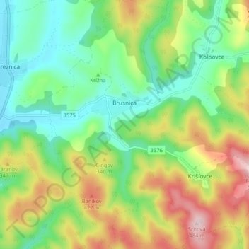
Name: Brusnica topographic map, elevation, terrain.
Average elevation: 938 ft
Minimum elevation: 564 ft
Maximum elevation: 1,585 ft
Make a donation
Gear up for your next adventure:
As an Amazon Associate, this site earns from qualifying purchases at no extra cost to you.