
Make a donation
Gear up for your next adventure:
As an Amazon Associate, this site earns from qualifying purchases at no extra cost to you.
Berendries topographic map
Click on the map to display elevation.
Make a donation
Gear up for your next adventure:
As an Amazon Associate, this site earns from qualifying purchases at no extra cost to you.
About this map
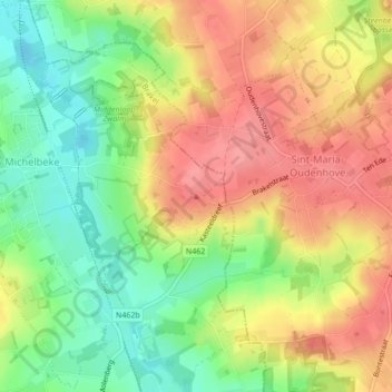
Name: Berendries topographic map, elevation, terrain.
Average elevation: 203 ft
Minimum elevation: 69 ft
Maximum elevation: 325 ft
Make a donation
Gear up for your next adventure:
As an Amazon Associate, this site earns from qualifying purchases at no extra cost to you.
Other topographic maps
Click on a map to view its topography, its elevation and its terrain.
Sint-Maria-Oudenhove (Brakel)
België > Oost-Vlaanderen > Oudenaarde > Sint-Maria-Oudenhove
Sint-Maria-Oudenhove ligt in de Vlaamse Ardennen op een hoogte van 23-100 meter. De belangrijkste waterloop is de Marebeek die westwaarts naar de Zwalm stroomt. De belangrijkste natuurgebieden zijn: de Zwalmvallei met het natuurreservaat Middenloop Zwalm en het Kloosterbos, eigendom van de stad Zottegem, het…
Average elevation: 197 ft