Geolocate

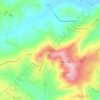
Sefro topographic map

Click on the map to display elevation.

About this map
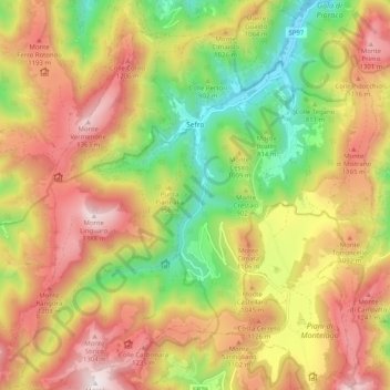
Name: Sefro topographic map, elevation, terrain.

Location: Sefro, Macerata, Marche, 62025, Italy (43.09683 12.90350 43.17069 12.99577)

Average elevation: 3,048 ft

Minimum elevation: 1,516 ft

Maximum elevation: 4,573 ft

Other topographic maps

Click on a map to view its topography, its elevation and its terrain.

Santa Maria in Piana

Italy > Marche > Macerata > Treia

Average elevation: 1,037 ft

Saline

Italy > Marche > Macerata > Penna San Giovanni

Average elevation: 1,319 ft

Paganico

Italy > Marche > Macerata > Camerino

Average elevation: 1,791 ft

Castelnuovo

Italy > Marche > Macerata > Recanati

Average elevation: 427 ft

San Martino

Italy > Marche > Macerata > Sant'Angelo in Pontano

Average elevation: 899 ft

Vecciola di Sopra

Italy > Marche > Macerata > Sarnano

Average elevation: 1,736 ft

Anselmi

Italy > Marche > Macerata > Monte San Martino

Average elevation: 1,329 ft

Aurora

Italy > Marche > Macerata > Civitanova Marche

Average elevation: 79 ft

Gear up for your next adventure:

🔭Telescopic Hiking Pole - Adjustable pole for hiking stability
📱Solar Portable Charger - Solar power bank for charging devices off‑grid
🛶Inflatable Kayak - Portable kayak for rivers, lakes, and expeditions
🦶Carbon Trekking Poles - Reduce knee impact on steep descents with ultra-light poles
🧭Hiking Compass - Precision compass for reliable navigation in the wilderness

As an Amazon Associate, this site earns from qualifying purchases at no extra cost to you.