
Make a donation
Gear up for your next adventure:
As an Amazon Associate, this site earns from qualifying purchases at no extra cost to you.
Restefond topographic map
Click on the map to display elevation.
Make a donation
Gear up for your next adventure:
As an Amazon Associate, this site earns from qualifying purchases at no extra cost to you.
About this map
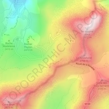
Name: Restefond topographic map, elevation, terrain.
Average elevation: 8,314 ft
Minimum elevation: 7,047 ft
Maximum elevation: 9,373 ft
Make a donation
Gear up for your next adventure:
As an Amazon Associate, this site earns from qualifying purchases at no extra cost to you.
Other topographic maps
Click on a map to view its topography, its elevation and its terrain.
Le Chevalier
France > Provence-Alpes-Côte d'Azur > Alpes-de-Haute-Provence > Jausiers
Average elevation: 8,222 ft
Chanenc
France > Provence-Alpes-Côte d'Azur > Alpes-de-Haute-Provence > Jausiers
Average elevation: 5,056 ft
Le Canton
France > Provence-Alpes-Côte d'Azur > Alpes-de-Haute-Provence > Jausiers
Average elevation: 4,931 ft
La Chalannette
France > Provence-Alpes-Côte d'Azur > Alpes-de-Haute-Provence > Jausiers > La Chalannette
Average elevation: 5,646 ft
Make a donation
Gear up for your next adventure:
As an Amazon Associate, this site earns from qualifying purchases at no extra cost to you.
Les Caïres
France > Provence-Alpes-Côte d'Azur > Alpes-de-Haute-Provence > Jausiers > Les Caïres
Average elevation: 5,568 ft
Les Buissons
France > Provence-Alpes-Côte d'Azur > Alpes-de-Haute-Provence > Jausiers > Les Buissons
Average elevation: 4,908 ft
Les Bellarots
France > Provence-Alpes-Côte d'Azur > Alpes-de-Haute-Provence > Jausiers
Average elevation: 4,843 ft
Guégnier
France > Provence-Alpes-Côte d'Azur > Alpes-de-Haute-Provence > Jausiers
Average elevation: 4,806 ft
Make a donation
Gear up for your next adventure:
As an Amazon Associate, this site earns from qualifying purchases at no extra cost to you.
La Croix
France > Provence-Alpes-Côte d'Azur > Alpes-de-Haute-Provence > Jausiers
Average elevation: 6,982 ft