Geolocate

Sibul topographic map

Click on the map to display elevation.

About this map

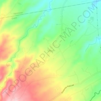
Name: Sibul topographic map, elevation, terrain.

Location: Sibul, Orani, Bataan, Central Luzon, 2112, Philippines (14.77177 120.43681 14.81177 120.47681)

Average elevation: 466 ft

Minimum elevation: 141 ft

Maximum elevation: 873 ft

Gear up for your next adventure:

❄️Traction Cleats - Prevent slips on icy trails during winter hikes
🧭Outdoor Navigation Book - Learn advanced navigation skills
🔥Camping Stove - Portable stove for camping and backcountry cooking
GPS Sports Watch - GPS watch for running, hiking and training
📡GPS Antenna Upgrade - Enhance GPS reception in remote terrain

As an Amazon Associate, this site earns from qualifying purchases at no extra cost to you.