
Thank you for supporting this site ❤️
Make a donation
Make a donation
Gear up for your next adventure:
As an Amazon Associate, this site earns from qualifying purchases at no extra cost to you.
Habitzheim topographic map
Click on the map to display elevation.
Thank you for supporting this site ❤️
Make a donation
Make a donation
Gear up for your next adventure:
As an Amazon Associate, this site earns from qualifying purchases at no extra cost to you.
About this map
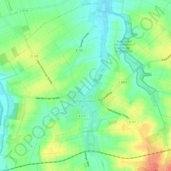
Name: Habitzheim topographic map, elevation, terrain.
Location: Habitzheim, Otzberg, Landkreis Darmstadt-Dieburg, Hesse, Germany (49.83656 8.84839 49.86972 8.90211)
Average elevation: 561 ft
Minimum elevation: 489 ft
Maximum elevation: 676 ft
Thank you for supporting this site ❤️
Make a donation
Make a donation
Gear up for your next adventure:
As an Amazon Associate, this site earns from qualifying purchases at no extra cost to you.
Other topographic maps
Click on a map to view its topography, its elevation and its terrain.