Geolocate

Habitzheim topographic map

Click on the map to display elevation.

About this map

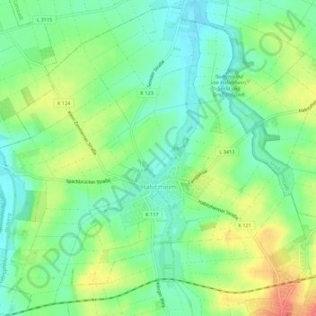
Name: Habitzheim topographic map, elevation, terrain.

Location: Habitzheim, Otzberg, Landkreis Darmstadt-Dieburg, Hesse, Germany (49.83656 8.84839 49.86972 8.90211)

Average elevation: 561 ft

Minimum elevation: 489 ft

Maximum elevation: 676 ft

Other topographic maps

Click on a map to view its topography, its elevation and its terrain.

Traisa

Germany > Hesse > Landkreis Darmstadt-Dieburg > Mühltal > Traisa

Average elevation: 709 ft

Gear up for your next adventure:

🪶Paracord Bracelet - Survival bracelet with built‑in tools
🧭GPS Watch Accessories - Bands and chargers for GPS watches
👟Men's Trail Runners - Lightweight footwear for fast-paced exploration and light hiking
🩹Survival Bandages - High‑quality bandages for emergencies
🌡️Handheld Weather Meters - Measure wind, temp, and pressure for safe mountain travel

As an Amazon Associate, this site earns from qualifying purchases at no extra cost to you.