
Thank you for supporting this site ❤️
Make a donation
Make a donation
Gear up for your next adventure:
As an Amazon Associate, this site earns from qualifying purchases at no extra cost to you.
Cocoșești topographic map
Click on the map to display elevation.
Thank you for supporting this site ❤️
Make a donation
Make a donation
Gear up for your next adventure:
As an Amazon Associate, this site earns from qualifying purchases at no extra cost to you.
About this map
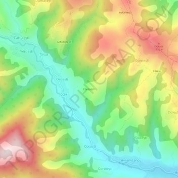
Name: Cocoșești topographic map, elevation, terrain.
Location: Cocoșești, Orgești, Avram Iancu, Alba, 517078, Romania (46.35417 22.79198 46.39417 22.83198)
Average elevation: 3,009 ft
Minimum elevation: 2,247 ft
Maximum elevation: 4,078 ft
Thank you for supporting this site ❤️
Make a donation
Make a donation
Gear up for your next adventure:
As an Amazon Associate, this site earns from qualifying purchases at no extra cost to you.