
Thank you for supporting this site ❤️
Make a donation
Make a donation
Gear up for your next adventure:
As an Amazon Associate, this site earns from qualifying purchases at no extra cost to you.
Chiquimulilla topographic map
Click on the map to display elevation.
Thank you for supporting this site ❤️
Make a donation
Make a donation
Gear up for your next adventure:
As an Amazon Associate, this site earns from qualifying purchases at no extra cost to you.
About this map
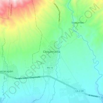
Name: Chiquimulilla topographic map, elevation, terrain.
Location: Chiquimulilla, Santa Rosa, 06008, Guatemala (14.04764 -90.42078 14.12764 -90.34078)
Average elevation: 1,073 ft
Minimum elevation: 374 ft
Maximum elevation: 3,284 ft
Thank you for supporting this site ❤️
Make a donation
Make a donation
Gear up for your next adventure:
As an Amazon Associate, this site earns from qualifying purchases at no extra cost to you.